
AR-Enhanced Wayfinding
Augmented Reality Directions, Points of Interest, and Safety Alerts in Real Time In bustling metropolises, the quest to find a hidden café or...
Augmented Reality Directions, Points of Interest, and Safety Alerts in Real Time
In bustling metropolises, the quest to find a hidden café or navigate a labyrinthine network of backstreets can feel like solving an evolving puzzle. Augmented reality wayfinding applications promise to overlay digital breadcrumbs, real-time waypoints, and contextual alerts onto the physical world. By fusing geospatial data with computer vision, these tools transform smartphones and wearable devices into intuitive compasses, guiding pedestrians and drivers alike through dense urban environments. Gone are the days of static maps and guesswork; instead, dynamic AR annotations adapt to changing conditions and personal preferences, turning city exploration into an interactive, storybook journey.
Real-Time Directional Overlays
Geospatial Anchoring and Tracking
Imagine a courier in Amsterdam weaving through canals and narrow bridges, guided by luminous arrows floating midair as if cast by an invisible hand. Geospatial anchoring leverages GPS, visual-inertial odometry, and simultaneous localization and mapping (SLAM) to continuously triangulate a user’s position within centimeters. By cross-referencing digital maps with live camera feeds, AR wayfinding platforms tether virtual arrows to fixed points in the environment. This synchronisation ensures that overlays remain stable and aligned even as the user tilts, rotates, or steps backward. Such precision mapping eradicates spatial disorientation, transforming each street corner into a reliable node in a luminous digital lattice.
The system fuses signals from GNSS satellites with sensor fusion algorithms processing accelerometer, gyroscope, and magnetometer data. In dense urban canyons where satellite reception falters, vision-based SLAM steps in, identifying and tracking features like lampposts or building facades. This hybrid geospatial strategy mitigates drift and jitter, sustaining overlay integrity. Urban navigators experience seamless transitions between indoor lobbies and open plazas, with virtual signposts steadfastly anchored in the real world. The result is a cohesive navigation narrative, where digital breadcrumbs guide users unerringly from origin to destination, regardless of architectural complexity or signal occlusion.
Latency and Visual Persistence
Latency can shatter immersion; a half-second lag makes arrows hover offshore from the intended pathway, evoking frustration. Cutting-edge AR frameworks minimize end-to-end latency by optimizing sensor data pipelines and leveraging GPU-accelerated rendering. Frame prediction algorithms anticipate head and device motion, adjusting overlay positions proactively to match anticipated viewpoints. Visual persistence emerges from blending past frames with predicted ones, ensuring graphics appear to “stick” to real objects even during swift movements. For the commuter sprinting to catch a tram, this perceptual consistency offers unwavering guidance, as if the city itself conspired to illuminate the correct route.
Engineers accomplish this by interpolating positional data at microsecond intervals, fusing past sensor readings with predictive analytics to generate frames ahead of time. By decoupling tracking computations from rendering threads, modern AR SDKs maintain fluid frame rates even on mid-tier hardware. Visual persistence techniques gently blur transitions between frames, masking minor positional discrepancies and preserving overlay cohesion. Consequently, users perceive a continuum of digital cues etched into the urban canvas, facilitating confident navigation through busy plazas, bustling crosswalks, and narrow alleyways without breaking stride or squinting at static maps.
Adaptive Pathfinding Algorithms
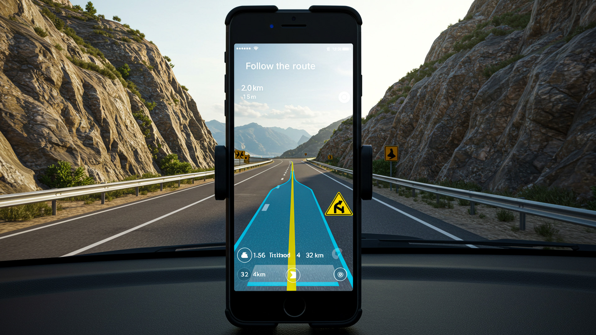
Traditional routing services calculate point-to-point paths but rarely adapt to ephemeral conditions—construction zones, crowded sidewalks, or unexpected detours. Adaptive pathfinding algorithms integrate live data streams such as traffic sensors, public transit schedules, and even pedestrian density analytics to dynamically recalibrate routes. When a half-marathon blocks city streets unexpectedly, an AR app can reroute cyclists through adjacent boulevards, projecting alternate trajectories onto windshields or smart glasses. This dynamic rerouting elevates wayfinding from a static instruction set to a living map that evolves with the city’s pulse.
Underneath the hood, graph traversal methods like D* Lite or incremental A* algorithms continuously evaluate node costs based on real-time inputs. These advanced constructs allow for swift replanning without recalculating entire paths. A runner escaping sudden rainfall may find the AR app highlighting sheltered walkways, while autonomous delivery bots can pivot to smoother surfaces. By embedding cost functions that account for elevation changes, lighting conditions, and user preferences, AR-enhanced pathfinding becomes not only efficient but also personalized, enriching urban mobility with adaptive intelligence.
Contextual Points of Interest Integration
Semantic Scene Understanding
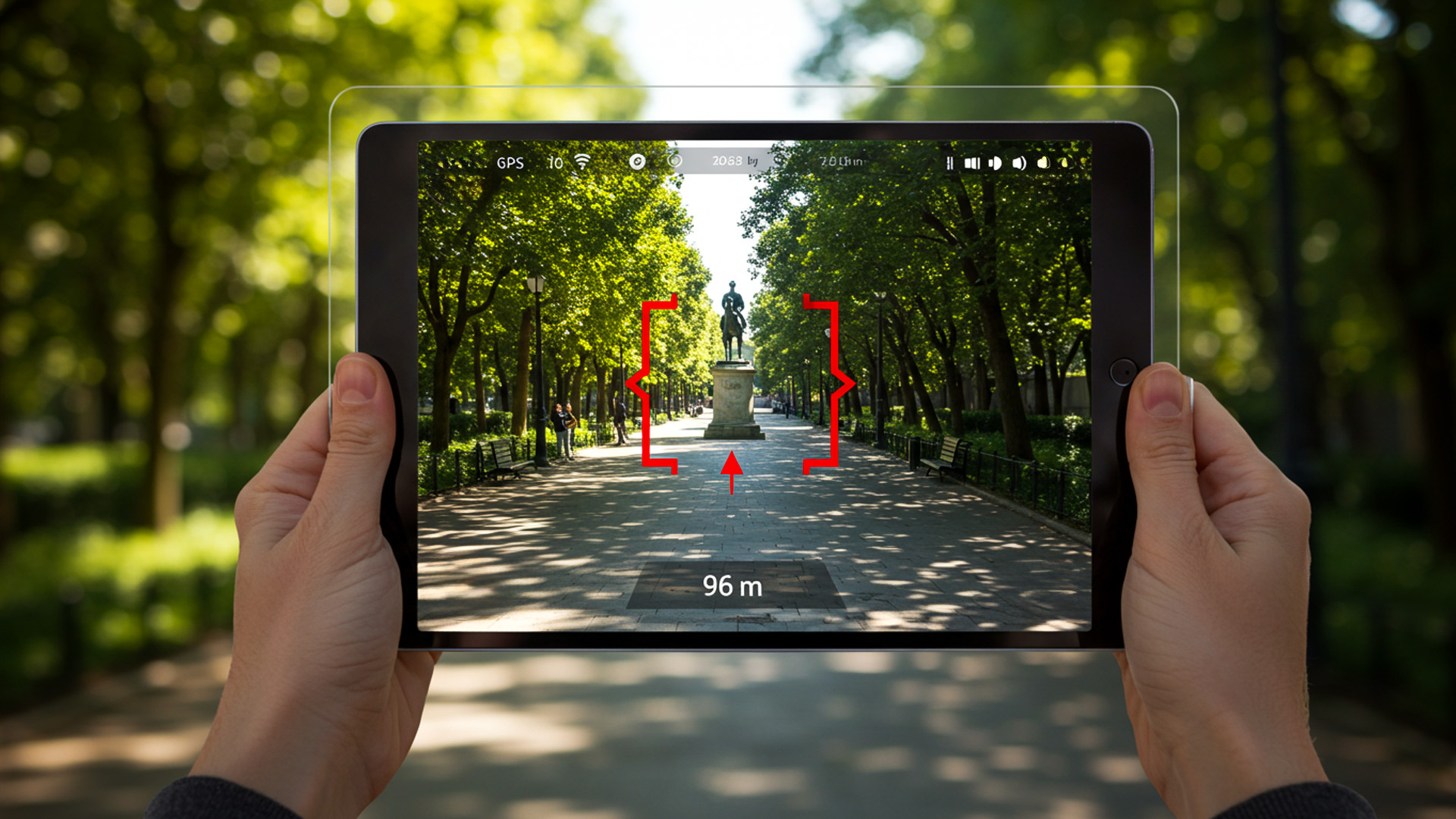
Consider a tourist in Tokyo discovering hidden ramen shops simply by pointing their phone toward a bustling alley. Semantic scene understanding employs machine learning to classify objects—storefronts, street signs, even park benches—within the camera feed. By mapping these recognized elements to geographic databases, AR apps can automatically label each storefront with names, hours, and user ratings. This semantic overlay turns any urban vista into an annotated map, revealing cultural nuances and local landmarks that static maps often obscure. The cityscape transforms into a living encyclopedia, bridging digital insight with tangible surroundings.
Behind the scenes, convolutional neural networks parse visual input, while natural language processing links recognized entities to information repositories. As new businesses open or change hours, cloud-based models update semantic layers in near real time, ensuring accuracy. The result is a fluid user experience where contextual cues glide seamlessly across shop windows and public art. By integrating semantic understanding, AR wayfinding transcends mere arrow overlays, empowering users to navigate not just streets but stories embedded in every facade and storefront.
User-Centric Relevance Filtering
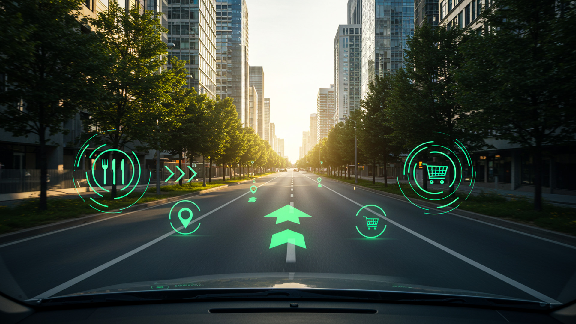
Not every restaurant or monument merits display during a hurried commute. User-centric relevance filtering applies preference models and behavioral analytics to curate Points of Interest (POIs). A vegan traveler will see plant-based eateries highlighted, while an architecture enthusiast might discover Bauhaus landmarks on their route. This personalization relies on collaborative filtering algorithms and on-device profiling, balancing privacy with precision. By filtering POIs according to individual tastes, AR wayfinding becomes a bespoke guide, tailoring each overlay to the user’s unique narrative rather than inundating them with irrelevant data.
Adaptive filtering models learn from click-through rates, dwell time, and explicit user feedback to refine recommendations. Geofencing techniques prioritize nearby venues, while time-aware heuristics suppress POIs unlikely to be open. The interface seamlessly toggles between “Explore” and “Navigate” modes, offering deep dives into local culture or streamlined paths to destinations. Through relevance filtering, AR wayfinding minimizes cognitive load, ensuring that only the most pertinent annotations grace the user’s view, akin to a personal concierge whispering suggestions at just the right moment.
Interactive Information Layers
Beyond static labels, interactive information layers let users tap, gesture, or voice-activate detailed data. Imagine standing before a Gothic cathedral and tapping its floating outline to reveal construction dates, architectural styles, or live crowd statistics. These layers employ spatialized UI elements that respond to gaze direction and hand movements, creating natural interactions within the user’s field of view. By enabling on-demand expansion, AR wayfinding transforms passive overlays into interactive portals, allowing exploration of rich content without leaving the sidewalk or detouring from one’s path.
Underpinning this interactivity are gesture recognition frameworks and low-latency voice APIs. Haptic feedback on wearables or subtle audio cues confirm user selections, ensuring intuitive control. Developers can author multilayered data cards—combining text, images, and live feeds—and anchor them contextually within the scene. This granularity fosters a dialogue between user and environment, where each tap or voice command uncovers a new dimension of urban insight, seamlessly blending navigation with discovery.
Dynamic Safety and Alert Systems
Proximity-Based Hazard Detection
Envision walking through a dimly lit alley and receiving a pulsing red halo around a slick puddle that sensors deem hazardous. Proximity-based hazard detection fuses LiDAR, ultrasonic rangefinders, and computer vision to identify obstacles, slippery surfaces, or incoming vehicles. AR wayfinding apps can then project cautionary symbols or audible alerts, enabling users to adjust their path proactively. Whether it’s alerting wheelchair users to curb heights or warning cyclists of debris on bike lanes, these systems enhance urban safety by anticipating hazards and overlaying real-time guidance to mitigate risk.
Dynamic hazard models continuously ingest environmental sensor feeds and crowdsourced incident reports to update risk assessments. Machine learning classifiers distinguish between transient obstacles—like a stray dog—and permanent fixtures, calibrating alert thresholds accordingly. When arterial roads become treacherous after rainfall, AR apps can reroute pedestrians via elevated walkways or covered passages. This anticipatory approach augments human perception, acting as an ever-vigilant sentinel that illuminates dangers before they materialize in the user’s path.
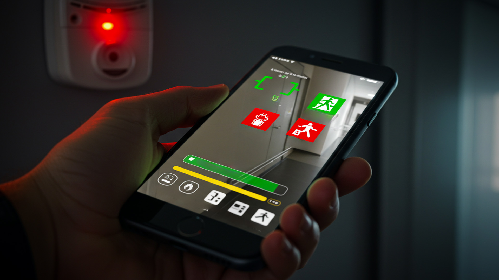
Personalized Alert Prioritization
Urban dwellers have diverse safety needs: parents guiding children, commuters with mobility impairments, or runners aiming for seamless pacing. Personalized alert prioritization classifies notifications by severity and relevance, ensuring critical warnings—such as approaching vehicles—override less urgent messages like nearby café promotions. By learning user profiles and situational context, AR wayfinding tailors its alert vocabulary, selecting appropriate visual icons, haptic pulses, or spatial audio cues. This intelligent filtering prevents alert fatigue, maintaining user trust and attention when it matters most.
Priority engines leverage semantic context—time of day, location type, and user activity—to adjust alert modalities. A late-night pedestrian receives brighter, high-contrast overlays, while a daytime tourist experiences subtler annotations. Integration with wearable health sensors can even delay nonessential alerts if the user’s heart rate indicates intense focus. Personalized prioritization transforms AR safety alerts from generic bulletins into contextually aware guardians, seamlessly woven into each urban journey.
Augmented Cultural and Regulatory Notifications
Cities thrive on cultural richness and regulatory complexity. AR wayfinding can overlay historical anecdotes at heritage sites or broadcast local noise ordinances near residential zones. For instance, a user strolling past an Art Deco theater might see a brief vignette about its architect, while a cyclist entering a bike-only street receives regulatory reminders projected onto the pavement. These culturally and legally informed annotations foster respectful exploration, ensuring users remain mindful of local norms and legislation without consulting separate guides or signage.
Developers curate content layers by integrating municipal open data portals and cultural heritage registries. Geofenced triggers activate audio narrations or multilingual text cards, accommodating diverse audiences. Regulatory notifications adapt to jurisdictional changes, pushing updates from civic servers in real time. By melding cultural storytelling with compliance reminders, AR wayfinding nurtures informed citizens who navigate cities with both wonder and responsibility.
User Experience and Future Prospects
Ergonomics of Wearable Displays
Smartphone AR is convenient, but hands-free wearables like smart glasses promise a more ergonomic future. Designers are tackling weight distribution, battery placement, and optical clarity to reduce neck strain and visual fatigue. Advanced waveguide optics project crisp overlays directly onto the retina, while bone-conduction audio delivers spatial cues without occluding ambient sound. These ergonomic refinements ensure that AR wayfinding can be worn for hours without discomfort, making everyday commutes feel like guided tours through a city of tomorrow.
Prototyping labs employ anthropometric data and user feedback loops to optimize frame geometry and nose bridge contours. Thermal management systems dissipate heat generated by on-device processing chips, maintaining comfort in warm climates. As display efficiency improves, wearables will shrink and lighten, ultimately resembling ordinary eyewear. This ergonomic evolution paves the way for ubiquitous AR wayfinding, where digital guidance seamlessly integrates into daily life with minimal physical intrusion.
Social Interaction and Shared Wayfinding
Wayfinding has always been a social act—asking locals for directions or sharing maps with friends. AR apps extend this social dimension by enabling shared navigation layers: friends can drop virtual pins, annotate walking tours, or leave ephemeral graffiti for each other. In emergency scenarios, first responders can broadcast safe evacuation routes visible only to authorized personnel. These collaborative overlays leverage peer-to-peer networking and decentralized data stores, transforming urban navigation into a cooperative endeavor that strengthens community bonds.
Developers integrate real-time location sharing, role-based access controls, and versioned annotation layers to manage collaborative wayfinding. Tour guides can host AR-enhanced scavenger hunts, while urban planners can visualize proposed changes in situ with public feedback. By embedding social interaction into navigation, AR wayfinding transcends solitary guidance, evolving into a platform for collective exploration and civic engagement.
Towards Mixed Reality Urban Ecosystems
Looking ahead, AR wayfinding will merge with mixed reality city planning, where digital twins of urban environments reflect real-time conditions. Planners can simulate pedestrian flows under proposed developments, while residents navigate both physical streets and digital overlays that visualize air quality or energy usage. These twin-layered ecosystems will enable data-driven decisions and community-driven experiences, blurring the line between built environments and virtual enhancements.
Future frameworks will support interoperable data formats and standardized geospatial APIs, allowing diverse applications to share contextual layers. Blockchain-based verification may ensure data integrity for critical overlays, while edge computing will push latency to near-zero. As mixed reality ecosystems mature, AR-enhanced wayfinding will become the connective tissue binding cities, citizens, and digital infrastructures into a cohesive, intelligent whole.
User Experience And Future Prospects
Author: Elisha Roodt
Durban's leading intelligence hub on immersive technology. Delivering comprehensive coverage, expert analysis, and breakthrough news on Virtual Reality (VR), Augmented Reality (AR), and the Metaverse.